Deforestation in the southern region of Amazonas state, long one of the best-preserved slices of the Brazilian Amazon, is spreading rapidly as illegal gold miners, farmers, ranchers and land grabbers advance in the region.The four municipalities leading destruction in this region – Apuí, Novo Aripuanã, Manicoré and Humaitá – together accounted for nearly 60% of deforestation alerts detected in Amazonas in the first six months of the year.Environmental advocates and Indigenous leaders say the destruction is threatening the way of life of communities that depend on the forest for survival and splintering an important ecological mosaic brimming with plant and animal species
In a remote corner of the Brazilian Amazon, federal police agents hovered in helicopters above a massive gash in the rainforest canopy. Below them, gaping craters and muddy pools of wastewater pockmarked the coffee-colored soil.
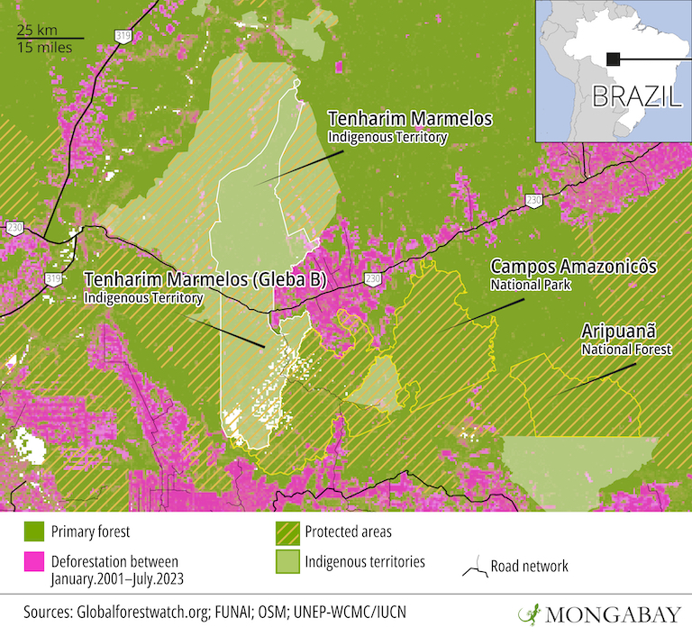
When the heavily armed squad touched down, it found a deforested area the size of 118 soccer fields, deep within the Tenharim Marmelos Indigenous Territory and Campos Amazonicôs National Park, two reserves that are supposed to be under strict federal protection.
Quickly, they set ablaze the makeshift camps and heavy machinery used by wildcat miners to extract gold from the mineral-rich soil deep in the rainforest. In total, authorities destroyed trucks, engines, pumps and dredges worth 8 million reais ($1.7 million) during this month’s high-profile mission.
The crackdown, part of an operation dubbed “Reclaim,” is the latest in a series of attempts by Brazil’s new government to halt the rapid advance of deforestation and environmental crime ravaging southern Amazonas state, a region that’s home to some of the Amazon’s best-preserved stretches of rainforest and a handful of its most important rivers.
“This is a really crucial region, both ecologically and for regulating the climate,” says Paulo Moutinho, senior scientist at the Amazon Environmental Research Institute (IPAM). “The rainforest is water. And as we see deforestation advancing, the forest is drying up.”
The four municipalities facing the highest levels of destruction in this region — Apuí, Novo Aripuanã, Manicoré and Humaitá — together recorded more than 1.25 million high-confidence deforestation alerts between Jan. 1 and June 20, according to satellite data from the University of Maryland visualized on the platform Global Forest Watch. This accounted for nearly 60% of alerts detected in Amazonas state, a Mongabay analysis of the data shows.

“This is a region with very little state presence,” says Virgilio Viana, superintendent at the Amazonas Sustainable Foundation (FAS) and a former environmental secretary for Amazonas state. The area has seen an explosion of illegal logging, land grabbing, gold mining, cattle ranching and agricultural expansion, he says. “And the impact has been enormous.”
In recent months, the invasions have intensified and moved deeper into protected areas like the Tenharim Marmelos Indigenous Territory, threatening the way of life of communities that depend on the forest for survival and splintering an important ecological mosaic brimming with plant and animal species.
“We are surrounded,” says Daiane Tenharin, a representative of the Tenharim Morogitá Indigenous People’s Association (Apitem) who has been monitoring the invasions through geographic information system (GIS) technology. “Our leaders are facing constant threats. We are under attack every single day.”
The destruction ravaging this part of the Amazon has also highlighted the challenges facing Brazil’s new president, Luiz Inácio Lula da Silva, as he scrambles to undo the policies of his predecessor, Jair Bolsonaro, whom many blame for encouraging deforestation and environmental crimes.
“The government inherited everything in shambles,” Moutinho says. “And it’s made the right steps. But it’s moving too slowly — and we’re running out of time to save the forest from reaching a point of no return.”
Historic tussle for land
In this far-flung corner of the Amazon, invaders have been encroaching on the forest for decades. The occupation can be traced back to the 1970s, first set in motion by a push from Brazil’s military dictatorship to populate the region as a way of staving off foreign invasion.
It began with the construction of the BR-230 highway, which sliced through the heart of the rainforest and connected it to the Brazilian coast, some 4,000 kilometers (2,500 miles) east. Soon after, the government also built the BR-319 highway, running through dense forest from Porto Velho, capital of Rondônia state, all the way to Manaus, the Amazonas state capital and the largest city in the rainforest.
“It was a period when environmental licensing didn’t exist,” says Fernanda Meirelles, the executive secretary of the BR-319 Observatory, a coalition of Brazilian and international NGOs that monitors deforestation along the highway’s trajectory. “So there weren’t any social or ecological considerations.”
The pair of highways ushered in a surge of deforestation. With the area now more accessible, a wave of migrants flocked in from the rest of Brazil, lured by promises of “land without men for men without land.” Ranchers and farmers rushed to raze the forest and turn it into pasture and cropland. Illegal loggers carved dirt roads deeper into the forest, in search of valuable tree varieties.
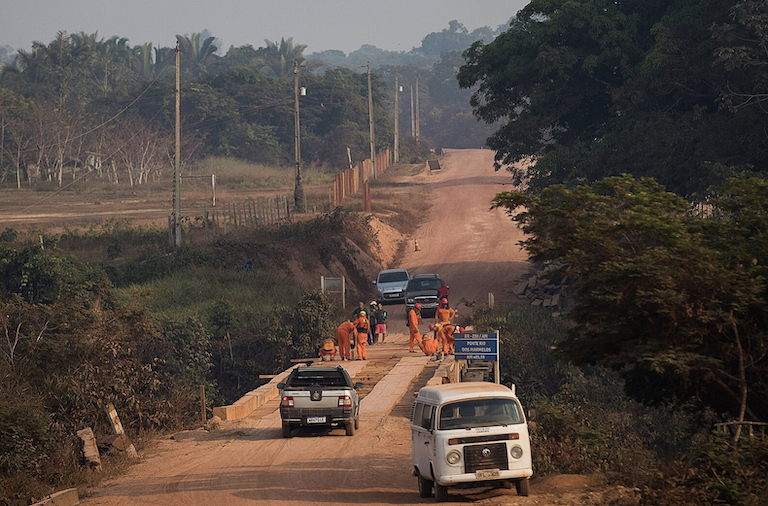
 Workers perform maintenance on a BR230 bridge over the Marmelos River in Tenharim Marmelos Indigenous Territory. Image by Bruno Kelly/Amazonia Real via Wikimedia Commons (CC 2.0).
The territory belonging to the Tenharim Indigenous people was at the frontlines of the pressure. When BR-230 was built, it sliced through their ancestral lands, ushering in a wave of invasion, destruction and land conflict.
“Our lands have been under attack ever since then,” Daiane Tenharin says by phone from the village of Campinho, in the Tenharim Marmelos Indigenous Territory. “It hasn’t stopped.”
The tussle over land in this region continued even after the Brazilian government demarcated a total of 1.06 million hectares (2.62 million acres) in the late 1990s and early 2000s as three Indigenous reserves for the Tenharim people. The territories were also meant to protect the Kaidjuwa and Igarapé Preto isolated peoples who live in these forests and for whom contact with outsiders — and the diseases they carry — can be especially dangerous.
But despite these new protections, dozens of settlers moved in, hoping the land they were illegally occupying would eventually be recognized as theirs. They cut down swaths of forest, built homes and planted crops, mostly within the Gleba B reserve, which sits directly north of Tenharim Marmelos and was the last of the Tenharim territories to be officially demarcated in 2012.
Today, there are roughly 200 families living illegally in the southern part of the Gleba B reserve and roughly 70% of this area has been deforested, according to Daiane. “They’ve put up fences around their farms … so we don’t have access to parts of our own territory,” she says. “There is no forest left anymore, there are no tall trees. All there is now is pasture.”
 Satellite imagery captured June 2023 by Planet Labs shows deforestation within the southern portion of the Tenharim Marmelos Gleba B reserve.
New narrative, tougher policing
The destruction, there and elsewhere in the Amazon, only intensified when Bolsonaro came into power in 2019, promising to open up protected lands to mining, agriculture and cattle ranching. Under his watch, environmental policing ground to a halt, invasions of Indigenous lands skyrocketed, and deforestation across the Amazon hit 15-year highs.
“Illegality got a social license from the previous government,” Viana says. “And this encouraged these actors to act more aggressively.”
Brazil’s new president, known popularly as Lula, quickly began making good on his promises to reverse course, halt deforestation and punish those encroaching on protected lands. Soon after taking office on Jan. 1, he announced a new ministry focused on Indigenous people and ordered a series of ambitious police operations across the Amazon.
And just six months into his presidency, there are signs that Lula’s greener rhetoric may be having a tangible impact on environmental crime: deforestation alerts dropped by about 39% between January and June, according to preliminary data from Brazil’s space agency, INPE.
In the first six months of the year, the federal environmental enforcement agency, IBAMA, carried out 390 operations in the Amazon region, which resulted in 8,092 infraction notices and more than 2.53 trillion reais ($534 billion) in fines, a spokesperson said in a statement to Mongabay. The agency’s budget for combating fires during the dry season, which in recent years have engulfed swaths of pristine jungle across the Amazon, has also increased by 113% compared to last year.
Still, Lula’s vision for the Amazon has faced staunch resistance from Congress, where groups aligned with powerful agricultural interests have continued to chip away at protections. In a devastating blow to Lula’s bold plans to end all illegal deforestation by 2030, this congressional bloc gutted the environmental and Indigenous ministries, slashing their funding in late May.
“The new government has already changed the narrative,” Viana says. “But it is still a very challenging task to put a stop to the dynamics … that were explicitly encouraged by the previous government.”
Lawmakers in the lower chamber of Congress have also passed several controversial bills that chip away at environmental protections and Indigenous rights, including a proposed law that would only allow Indigenous people to claim lands they were physically living on when Brazil’s Constitution was signed in 1988, a cutoff date known as the marco temporal. The bill is now up for a vote in the Senate.
The advance of the bill had a concrete impact on Daiane Tenharin’s people, she says. Emboldened by its advance, land grabbers and wildcat miners began to invade Tenharim Marmelos, the first of her people’s reserves to be officially demarcated in 1996, and long the Tenharim’s best protected slice of territory.
Marco temporal “only increased their interest in our lands,” Daiane says. “Here in this region, people were even celebrating … They say that, even if it’s Indigenous land, this would create a loophole.”
Advancing destruction
As lawmakers wage a political tug-of-war over environmental policy, deforestation has continued largely undeterred in Amazonas, the second-most deforested state across the region in the first five months of the year, according to an analysis by Imazon, a nonprofit research organization.
In recent months, the destruction has spilled over into important conservation reserves like Aripuanã National Forest, which was created in 2016 to safeguard traditional peoples, guarantee water resources and preserve the rich biodiversity of the region. Invasions have also intensified within public forests that are not yet under official government protection, Moutinho says.
“These undesignated areas are really vulnerable,” he says. “They remain in a legal limbo, where people think that it is no-man’s-land. So they go in and start to deforest.”
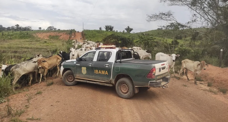
Though still reeling from deep budget cuts in recent years, federal agencies have signaled they will not sit idly by. IBAMA earlier this year seized 3,000 head of cattle from embargoed areas totaling 25,000 hectares (62,000 acres) in Manicoré and Lábrea, which had been occupied illegally.
 Cattle surround an IBAMA vehicle during an operation. Image by Divulgação/IBAMA.
In Aripuanã National Forest, which has also suffered pressure, federal agents have already carried out three operations and are planning further missions, says Karyna Angel, spokesperson for ICMBio, the federal agency overseeing protected areas.
“The Aripuanã National Forest is located in the new agricultural frontier of the Amazon,” she wrote in a statement, noting deforestation is jeopardizing the sustainable development of the region.
Sonia Guajajara, who heads Lula’s newly created Indigenous affairs ministry, has promised to visit the Tenharim Indigenous lands next month, touring the region by helicopter to evaluate the extent of the crisis within the territory, Daiane says.
But, crucially, Lula has not yet sent a clear signal about his plans to pave a stretch of the BR-319 highway that runs through the southern part of Amazonas state, leaving the door open to land speculation.
The highway project, intended to improve a degraded slice of BR-319 and ease the transportation of timber — and, eventually, soy — out of the remote region, has been stalled for years by environmental concerns. But it made important advances under Bolsonaro, spurring a frenzy of speculative land grabbing in the region. So far, Lula has remained ambiguous on the future of the project.
Brazil’s Ministry of Environment and IBAMA, which is responsible for reviewing the project’s environmental licensing, did not respond to questions from Mongabay about the status of the project.
When asked about the project, an IBAMA representative responded with a statement that said federal agencies are currently preparing environmental studies but the process is “still at a very preliminary stage.” However, the statement acknowledged that deforestation in this region has increased, especially in the regions of Humaitá and Apuí, which the agency sees as “priorities in the fight against deforestation.”
“We are working on various strategies to combat deforestation, notably with the embargo of illegally deforested areas,” the statement read.
Paving this stretch of BR-319 risks ushering in more destruction, according to Meirelles, including giving rise to the construction of regional roads branching off it. It would also act as a symbolic move, consolidating a destructive economic model in the region, built around soy, cattle and timber.
“The BR-319 is the path to linking the arc of deforestation … to an area that, until now, has been protected,” she says. “This will certainly heat up the occupation of the region.”
Banner image of BR230 in Terêrim Marmelos Indigenous Territory. Image by Bruno Kelly/Amazonia Real via Wikimedia Commons (CC 2.0).
Editor’s note: This story was powered by Places to Watch, a Global Forest Watch (GFW) initiative designed to quickly identify concerning forest loss around the world and catalyze further investigation of these areas. Places to Watch draws on a combination of near-real-time satellite data, automated algorithms and field intelligence to identify new areas on a monthly basis. In partnership with Mongabay, GFW is supporting data-driven journalism by providing data and maps generated by Places to Watch. Mongabay maintains complete editorial independence over the stories reported using this data.
Feedback: Use this form to send a message to the editor of this post. If you want to post a public comment, you can do that at the bottom of the page.
Agriculture, Cattle, Crops, Environment, Governance, Green, Indigenous Communities, Indigenous Peoples, Indigenous Reserves, Land Conflict, Land Grabbing, National Parks, Primary Forests, Protected Areas, Rainforests, Roads, Tropical Forests, Wildlife
>>> Read full article>>>
Copyright for syndicated content belongs to the linked Source : MongaBay – https://news.mongabay.com/2023/07/in-brazils-amazon-a-new-deforestation-frontier-threatens-protected-lands/


