Published Jun 30, 2023 • Last updated 10 hours ago • 1 minute read
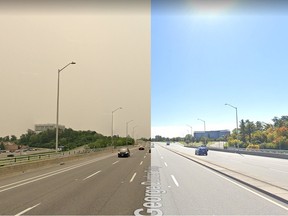
 The smoke and smog covering Ottawa has been documented in Google Maps – Screenshots of the George Dunbar Bridge show the difference in air quality from June 2023, and September 2022 Photo by Screen capture courtesy of Google Street View
In an odd case of serendipity, Google Maps’ omni-present Street View cameras appear to have documented the capital’s hazy, smoggy air conditions in almost real time.
Advertisement 2
This advertisement has not loaded yet, but your article continues below.
THIS CONTENT IS RESERVED FOR SUBSCRIBERS ONLY
Subscribe now to read the latest news in your city and across Canada.
Exclusive articles from Elizabeth Payne, David Pugliese, Andrew Duffy, Bruce Deachman and others. Plus, food reviews and event listings in the weekly newsletter, Ottawa, Out of Office. Unlimited online access to Ottawa Citizen and 15 news sites with one account. Ottawa Citizen ePaper, an electronic replica of the print edition to view on any device, share and comment on. Daily puzzles, including the New York Times Crossword. Support local journalism.
SUBSCRIBE TO UNLOCK MORE ARTICLES
Subscribe now to read the latest news in your city and across Canada.
Exclusive articles from Elizabeth Payne, David Pugliese, Andrew Duffy, Bruce Deachman and others. Plus, food reviews and event listings in the weekly newsletter, Ottawa, Out of Office. Unlimited online access to Ottawa Citizen and 15 news sites with one account. Ottawa Citizen ePaper, an electronic replica of the print edition to view on any device, share and comment on. Daily puzzles, including the New York Times Crossword. Support local journalism.
REGISTER TO UNLOCK MORE ARTICLES
Create an account or sign in to continue with your reading experience.
Access articles from across Canada with one account. Share your thoughts and join the conversation in the comments. Enjoy additional articles per month. Get email updates from your favourite authors.
At least in one spot.
Alert users have been surprised recently to discover the Street View version of southbound traffic on George Dunbar Bridge, crossing the Rideau River, is moving in the smoggy atmosphere we’ve grown accustomed to.
The identifier on the screen indicates the shot was taken in June 2023.
Travel (virtually) a little further and you’re driving in bright sunshine. That footage was taken in September 2022.
Google media representatives were not immediately available for comment Friday, but there has been much written about the massive coordination required for the huge worldwide project.
There’s no definitive schedule for when Google Map cars will be in a particular neighbourhood. The well-known vehicles, each with ar trademark two-metre camera tower on the roof, basically head out almost randomly.
Street View cars can be delayed by weather, traffic, and other conditions, but, generally, Google Maps updates every one to three years, depending on the location.
More curiously, in this case, stitching together the images is an intricate process that can take weeks or more, making the smoggy capture now on view a bit of an outlier.
Recommended from Editorial

What’s open and closed Canada Day in Ottawa

Ottawa police not aware of any planned Canada Day protests or disruptions, but ready to ‘monitor and adjust’
>>> Read full article>>>
Copyright for syndicated content belongs to the linked Source : OttawaCitizen – https://ottawacitizen.com/news/local-news/google-street-view-lands-lucky-real-time-view-of-ottawa-smog-conditions


