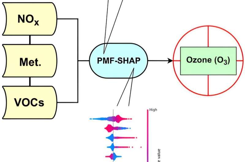
Graphical abstract. Credit: Environmental Pollution (2023). DOI: 10.1016/j.envpol.2023.122223
With its notoriously hot and humid climate and robust industrial environment, Houston is one of the most ozone-polluted cities in the United States. Now, a University of Houston research team is integrating the power of machine learning (ML) with innovative analysis techniques to pinpoint the city’s air pollution sources more accurately.
While the ozone layer in the stratosphere protects the Earth, and us, from the harmful rays of the sun, it’s also a major pollutant that can be harmful to human health when it’s closer to the ground. Long-term exposure to surface ozone can cause difficulty breathing, worsen asthma and increase the risk of heart disease, according to the Environmental Protection Agency.
The research team integrated the Positive Matrix Factorization (PMF) model with the SHAP algorithm of machine learning, which helps explain why ML models make certain decisions while also making the data more understandable. Their analysis revealed that in industrial areas, Houston’s oil and gas industry had the highest impact on emissions, while shortwave radiation and relative humidity were the two most important influencing factors for overall ozone concentration. The work is published in the journal Environmental Pollution.
Combining these two methods to get a deeper understanding of what is causing ozone pollution is an innovative approach that hadn’t been tried in Houston before, the researchers shared.
“We basically use the new technologies to identify major sources of emissions in the Houston area based on the different species or types of pollutants. It’s like a fingerprint, if certain species show up together that’s indicative of a certain pollution source,” said Delaney Nelson, a doctoral student at the Department of Earth and Atmospheric Sciences of UH’s College of Natural Sciences and Mathematics and first author of the paper. “Then we utilized SHAP to identify what emission sources are affecting the city most and at what magnitude.”
Ozone concentrations in different areas can vary depending on several factors, including whether an area is urban, rural, or industrial, as well as atmospheric conditions. Houston is unique because it includes all of these areas and has a warm, humid climate that attracts ozone buildup. Ozone, a gas made up of three oxygen molecules, is formed via photochemical reactions among nitrogen-based compounds and volatile organic compounds (VOCs)—these are the two compounds that the UH atmospheric science team tracked for the study.
The nitrogen-based compounds essentially are from vehicular emissions, but the VOCs are harder to pinpoint.
“Given the extent to which VOCs contribute to creating ozone, it’s critical to learn where these chemicals are coming from and what are the influencing factors,” said Yunsoo Choi, corresponding author and professor of atmospheric chemistry, AI deep learning, air quality modeling and satellite remote sensing. “Once we know the specific emission sources and factors, we can develop targeted strategies to reduce emissions, which will in turn reduce ozone in the air and make it healthier for everyone.”
The researchers used multi-year VOC measurements data from the Texas Commission on Environmental Quality (TCEQ)’s monitoring stations located in an industrial area and an urban area. The Lynchburg Ferry site was chosen as representative of Houston’s industrial sector since it is located on a peninsula that leads into the Houston Ship Channel, one of the busiest seaports in the world. And the Milby Park station was chosen to represent a typical urban area because it’s just southeast of downtown and surrounded by residential and commercial areas.
The team’s two-step approach with modeling and analysis showed a chemically definitive difference between the ship channel area and the urban site. Moreover, the chemical emissions were not just impacting the general ship channel site, but also areas downwind.
Both Nelson and Choi are thrilled that their innovative approach proved to be efficient and accurate for identifying emission sources and factors influencing ozone concentrations.
“Pollution is a critical issue in Houston, where you have extreme high heat and high concentration of ozone in the summers,” Choi said. “The types of insights we got are very useful information for the local community to develop effective policies. That’s why we put our time, effort and technological expertise into this project.”
He is eager to apply the two-step method to other areas. “Austin, San Antonio and Dallas all have different characteristics, so I expect the VOC sources will also be different,” Choi said. “Identifying VOC sources in different cities is very important because each city should have its own unique pollution fighting strategy.”
Nelson, who calls Houston home, is glad they started with “H-town.” However, she can envision expanding her research further to compare rural areas and urban areas, do a statewide study, and then go national—state by state.
“All of this is a huge puzzle and I love solving puzzles,” she said.
More information:
Delaney Nelson et al, A comprehensive approach combining positive matrix factorization modeling, meteorology, and machine learning for source apportionment of surface ozone precursors: Underlying factors contributing to ozone formation in Houston, Texas, Environmental Pollution (2023). DOI: 10.1016/j.envpol.2023.122223
Citation:
A comprehensive approach to tackling pollution in Houston and beyond (2023, November 6)
retrieved 6 November 2023
from https://phys.org/news/2023-11-comprehensive-approach-tackling-pollution-houston.html
This document is subject to copyright. Apart from any fair dealing for the purpose of private study or research, no
part may be reproduced without the written permission. The content is provided for information purposes only.
>>> Read full article>>>
Copyright for syndicated content belongs to the linked Source : Phys.org – https://phys.org/news/2023-11-comprehensive-approach-tackling-pollution-houston.html


