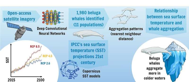
Relation between beluga whale aggregations and sea temperature on climate change forecasts. Credit: Frontiers in Marine Science (2024). DOI: 10.3389/fmars.2024.1359429
Until recently, technology limitations have made it challenging to effectively study the aggregation behavior of beluga whales. As climate change continues and sea surface temperatures rise quickly, the ability to do so becomes a priority, requiring methods that can capture data completely and accurately.
To this end, a team of researchers from Spain’s Universities of Cadiz, Alicante, and Leon has used deep convolutional neural networks (CNNs) to analyze open-access satellite imagery from Arctic areas of Canada, Russia, and the U.S. state of Alaska in order to positively identify the presence of beluga whales in these areas, compare sea surface temperatures (SSTs) to beluga aggregation patterns, and—based on data from the Intergovernmental Panel on Climate Change (IPCC)—create three representative concentration pathway (RCP) scenarios through the end of the 21st century.
The work appears in Frontiers in Marine Science.
As of 2017—the year of its most recent assessment of this species—the IUCN had classified beluga whales (Delphinapterus leucas) within its Red List conservation category of Least Concern. However, these whales make their home in isolated Arctic waters and depend on sea ice for protection from predators such as orcas, and for nutrition. Algae growing within the ice draw fish that are a mainstay of the belugas’ diet.

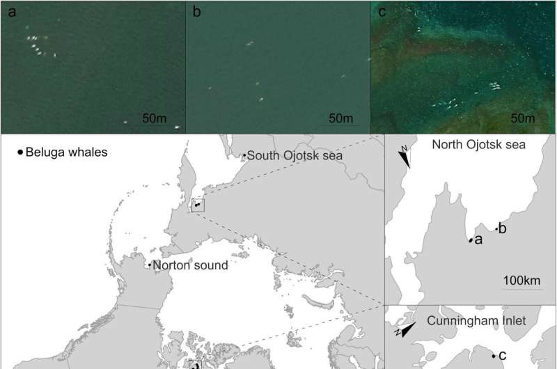
Beluga whale aggregations in the Arctic Ocean detected in very high-resolution satellite imagery from Google Earth. (A–F) beluga whale aggregations. Credit: Frontiers in Marine Science (2024). DOI: 10.3389/fmars.2024.1359429
Research published in 2020 has found that before the end of this century, ice could conceivably disappear from the Arctic during summers.
Research teams have previously used direct-observation aerial surveys to study cetaceans; however, this method is expensive, time-consuming, and can result in incomplete data due to its range limitations. Especially in rapidly warming seas, the accuracy of species-distribution models (SDMs) created through aerial surveys is time-limited.
At the end of the 20th century, researchers began using remote sensing imagery to collect data on individual whales and aggregations, but for studies involving marine mammals, employing this method on its own has also proven inaccurate.
Satellite images meet a deep CNN
Wondering if applying AI image analysis to satellite images might provide a solution, the research team behind this new study accessed high-resolution (less than 1 meter/pixel) satellite images of Arctic coasts obtained between 2007 and 2020. They first trained a deep CNN model to identify beluga whales based on a set of free images from Google Earth and Mapbox. Of 1,400 images in the set, half were of belugas and the other half were of icebergs.
The researchers built up the volume of the training data by randomly flipping some of the images, rotating others to random factors between zero and 360 degrees, cropping some of them, and adjusting image scales and brightness levels. After testing the model, they trained it further using 700 aerial images “in which each beluga whale is annotated within a bounding box (the total number of bounding boxes is 846),” they write.
Two of the researchers visually assessed and annotated each image with data on its class (icebergs or whales) and the number of whales, using whale-watching websites to verify the presence of belugas in the pictured areas. They compared images from the same spots on different dates to discern belugas from the sea floor. This work became important to determining the model’s accuracy later in the process.
Finally, the team applied their model to images in which the whales were most probably present, and used it to detect and count the whales within specific grid cells and to analyze aggregation patterns. However, icebergs presented a problem.
“Unfortunately, in areas where icebergs of similar size to beluga whales were present, the accuracy of the models was not good (less than 50% accuracy), and the images were photo-interpreted to detect beluga whales manually,” the researchers note.
Altogether, the team detected 1,980 belugas within eleven aggregations in specific Arctic areas of Canada, Russia, and the US; six of these aggregations were revealed by the satellite imagery and deep learning model.
They also confirmed a “significant relationship” between beluga aggregations and sea surface temperatures, which points to more aggregations in colder waters.
Noting that sea surface temperature mean records in these areas have increased in recent decades, they write, “Our results highlighted that SST is expected to increase at least one degree before 2050 in the three scenarios, but will increase from 1.5° to 3° C from 2050 to 2100, depending on the RCP scenario, with northern areas comprising the most affected under the three RCP scenarios.”
Lessons learned
With regard to improving the process of whale detection, the team observes that due to low spatial resolution of available images of beluga whales (which are approximately 5 meters long), automating this process will require new strategies, such as a focus on identifying them in groups rather than individually. Individuals can be too easily confused with icebergs due to their color, shape and size.
The researchers also discuss recent changes to sea ice; in many areas it now retreats earlier and advances later than in previous decades. On the basis of data in the IPCC report published in 2021, this new study projects that the locations of the eleven beluga aggregations could experience water temperature increases up to 3° C by the end of this century.
“This could, in turn, push their distribution patterns towards cooler southern areas, overlapping with northward distribution shifts of other marine mammal species, increasing habitat and resource competition or even leading to drastic population depletion, depending on species ability to adapt to new climate scenarios,” the team writes.
“Under this scenario, we recommend a prompt and global reduction of gas emissions and the protection of beluga whale territories from marine traffic if we wish to preserve this vulnerable species,” they conclude.
More information:
Marga L. Rivas et al, Relation between beluga whale aggregations and sea temperature on climate change forecasts, Frontiers in Marine Science (2024). DOI: 10.3389/fmars.2024.1359429
© 2024 Science X Network
Citation:
New study suggests warming seas are negatively affecting beluga whales’ aggregation patterns (2024, March 5)
retrieved 5 March 2024
from https://phys.org/news/2024-03-seas-negatively-affecting-beluga-whales.html
This document is subject to copyright. Apart from any fair dealing for the purpose of private study or research, no
part may be reproduced without the written permission. The content is provided for information purposes only.
>>> Read full article>>>
Copyright for syndicated content belongs to the linked Source : Phys.org – https://phys.org/news/2024-03-seas-negatively-affecting-beluga-whales.html


