Recent leaks claim Google is working on further integrating satellite connectivity to their Pixel phones and could introduce support for the tech in Google Maps. This information comes from two industry insiders: AssembleDebug who shared his findings with PiunikaWeb and Nail Sadykov over on Telegram. Beginning with the former, users will apparently be able to share their location with others via satellite connection.
Hints of the location-sharing tool were found in the strings of code on the latest Google Maps beta. It’s unknown exactly how it’ll work. The report doesn’t go into detail. They do, however, say people “will be able to update their location” in the app every 15 minutes to maintain accuracy. But there’s a catch – you can only refresh your whereabouts “up to five times a day.” It makes sense why Google would implement some sort of restrictions.
This is supposed to be an emergency, potentially life-saving feature akin to Emergency SOS on the iPhone and Google may not want people messing around with it.
Setting up a satellite connection
As for the other update, Nail Sadykov states he found evidence of something called the Android Satellite Pointing UI.
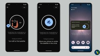
It appears to be a help guide for Pixel that’ll teach people how to connect their smartphone to an orbiting satellite. A video posted to the unofficial Google News channel on Telegram shows how the process could work.
Users will have to hold their phone in front of them and physically move it around to find a satellite. Once found, you’ll need to keep moving the device until a blue satellite icon reaches the middle of an on-screen circle and stays there for several seconds. Holding the icon in place allows the device to establish connection. If you don’t connect, you’ll receive an on-screen message telling you the session failed.

(Image credit: Nail Sadykov)
Sadykov goes on to say the guide will be a part of the Pixel’s “Adaptive Connectivity Service (ACS) app”. It’s unclear if he meant the currently available feature or if there will be a new app solely for ACS.
Get the hottest deals available in your inbox plus news, reviews, opinion, analysis and more from the TechRadar team.
He says it’ll be possible to minimize the window into a floating widget on the home page so you can continue texting while trying to establish a connection. When it’s all done, Pixel owners can see Satellite SOS running by swiping down on Quick Settings. You’ll also receive a short message in the menu telling you to avoid buildings, trees, and mountains to ensure a clear view of the sky and not interrupt service.
Potential arrival date
An arrival date for everything you see here is unknown, although both sources believe their respective features will launch on the Pixel 9. The two groups mention a third leak from April 15 about the Pixel 9 series possibly receiving the Samsung Modem 5400 to enable satellite connectivity. The same satellite icon (albeit red) and guide animations from Sadykov’s post were found in the earlier report. PiunikaWeb also mentions seeing the same symbol.
So what we’re seeing today could be the fruits of this new labor – at least potentially. Things could always change at the last minute. Be sure to take all this info with a grain of salt.
While we have you, check out TechRadar’s roundup of the best Pixel phones for 2024.
You might also like
Google’s next foldable could be the Pixel 9 Pro Fold and finally get flagship specsThe Google Pixel 8a leaks twice, hinting at its design, and four color optionsGoogle Maps AI upgrades could solve your EV charging headaches
>>> Read full article>>>
Copyright for syndicated content belongs to the linked Source : TechRadar – https://www.techradar.com/computing/software/pixels-new-satellite-feature-could-show-people-where-you-are-on-google-maps


